ISC Class 12 Geography Important Questions 2027 (Repeated in Board Exams)
Last updated:
90 question patterns that appeared in two or more of the analysed papers (4 board + 5 official sample papers (2023–2027)). The numbers change; the question does not.
Locational Setting of India
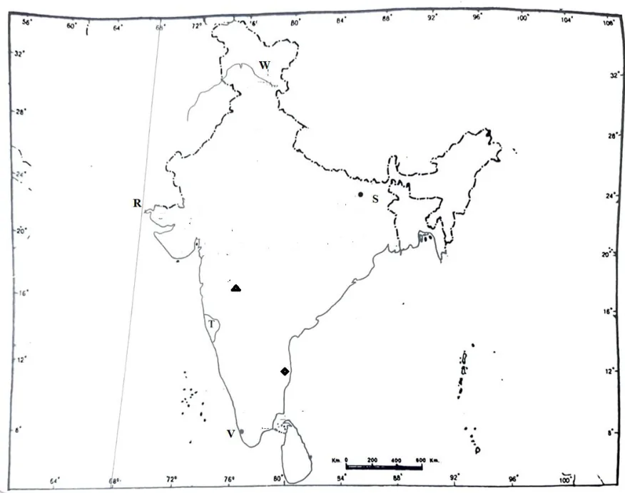
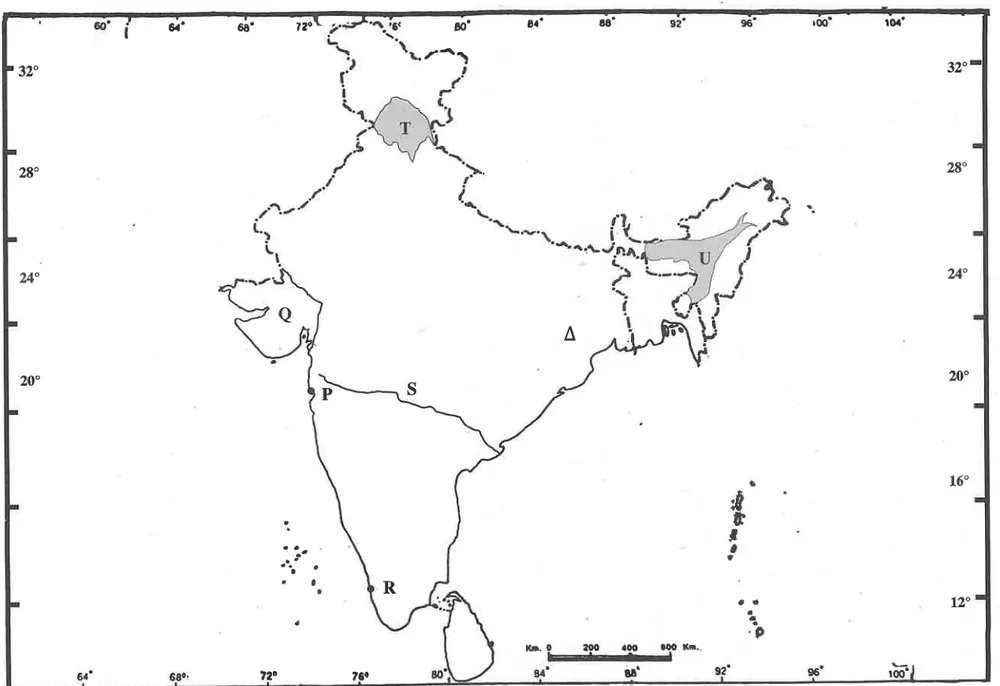
1. Map: identify the latitude/longitude marked (8°4'N, 37°6'N, 68°7'E, 97°25'E, 23°30'N, 82°30'E)
6×Board 2023Board 2025Sample 2023Sample 2024Sample 2025Sample 20261 marks
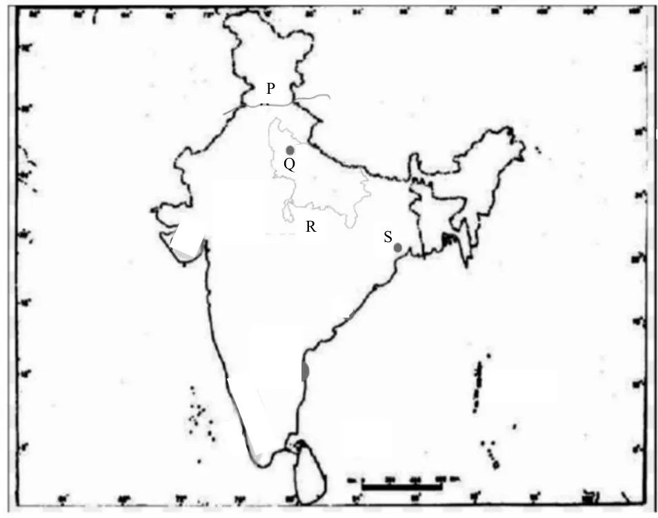
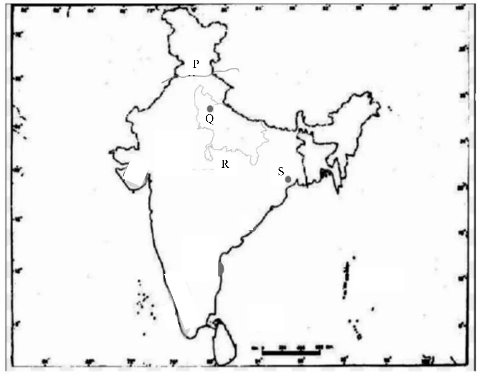
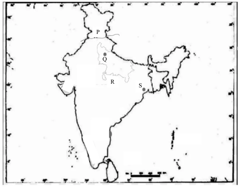
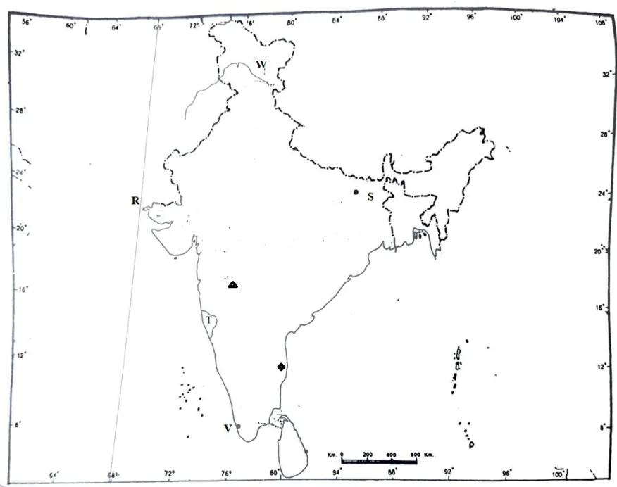
Refer to the given outline Map of India, identify the correct option and label on the Map. The longitude of India marked R:
(a) 68°7'E
(b) 78°30'E
(c) 23°30'N
(d) 97°25'E
2. Significance of India's location in the Indian Ocean ('Mistress of the Eastern Seas')
5×Board 2025Board 2026Sample 2024Sample 2025Sample 20262 marks
Indian Ocean acts as a global link. Justify the statement by giving two reasons.
3. MCQ: India's land borders with neighbouring countries
2×Sample 2023Sample 20241 marks
The country that India does NOT share a land border with is:
(a) Nepal
(b) Bhutan
(c) Sri Lanka
(d) Afghanistan
Structure and Physiography of India
4. Map: mark and label a water body (Palk Strait, Gulf of Kachchh/Khambhat, Chilika, Pulicat)
8×Board 2024Board 2025Board 2026Sample 2023Sample 2024Sample 2025Sample 2026Sample 20271 marks
Mark and label the correct option on the outline map provided. A large brackish waterbody on the Coromandel coast is:
(a) Pulicat
(b) Wular
(c) Chilika
(d) Sambar
5. Map: mark and label a mountain range (Aravallis, Satpura, Western Ghats, Nilgiris, Himadri, Karakoram)
8×Board 2023Board 2024Board 2025Board 2026Sample 2023Sample 2024Sample 2025Sample 20261 marks
Mark and label on the outline Map of India: The hills where Eastern Ghats and Western Ghats meet.
6. Map: mark and label a coastal plain (Konkan, Kanara, Malabar, Coromandel, Northern Circars)
6×Board 2023Board 2024Sample 2023Sample 2024Sample 2025Sample 20271 marks
Mark and label the correct option on the outline map provided. The coastal plains where the port of Kochi is located:
(a) Konkan
(b) Kanara
(c) Malabar
(d) Northern Circars
7. Map: mark and label a plateau (Malwa, Chota Nagpur, Deccan)
5×Board 2023Board 2025Board 2026Sample 2026Sample 20271 marks
Mark and label the correct option on the outline map provided. The plateau that lies to the north of Vindhya Mountain is:
(a) Malwa
(b) Deccan
(c) Meghalaya
(d) Chotanagpur
8. Badlands/ravines of the Chambal valley and Malwa plateau
2×Sample 2024Sample 20271 marks
How does the eroded landscape of Malwa plateau pose a challenge to farming?
9. How doabs/rivers made the Punjab plain fertile and commercial
2×Board 2026Sample 20272/4 marks
Assess how the formation of doabs has transformed Punjab from a subsistence landscape to a commercialised agrarian economy.
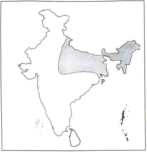
10. Sketch map: identify the shaded relief region (Malwa, Deccan, Himalayas) and give its features
3×Board 2023Board 2024Sample 20243/4 marks
Identify the shaded part in the map given above. State any two characteristic features of this relief division. What is its significance?
11. Bhabar: identify it and explain its features / unsuitability for farming
2×Board 2025Sample 20262 marks
The Bhabar region plays a significant role in the area's ecosystem; yet it is not considered suitable for agriculture. Justify the statement by giving two reasons.
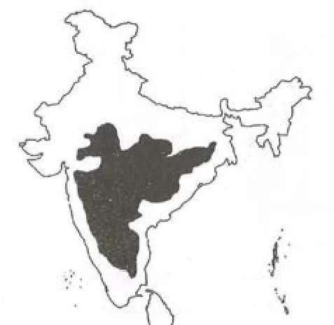
12. Explain the geological formation of the Peninsular Plateau
2×Sample 2024Sample 20252 marks
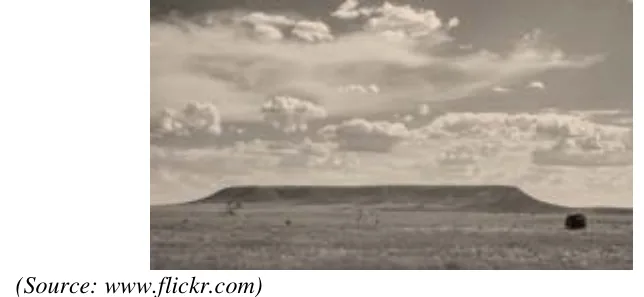
Identify the image given below and explain the formation of this geological division in India.
13. Physiographic features crossed on a journey across peninsular India
2×Board 2026Sample 20252 marks
Manisha embarked on a coast-to-coast road trip. She journeyed from the west coast and passed through rugged hills, experienced undulating topography and finally reached the shores of the Bay of Bengal. Name any one physiographic feature that Manisha would have encountered on her trip. State any one of its characteristic features.
14. Assertion-Reason: geological formation of India's physical divisions
2×Board 2024Sample 20241 marks
Assertion: The Himalayas were formed due to the collision of tectonic plates.
Reason: Indian plate moved northwards and pushed beneath the Eurasian Plate leading to the compression of sediments in the Tethys Sea.
(a) Both Assertion and Reason are true, and Reason is the correct explanation for Assertion.
(b) Both Assertion and Reason are true, but Reason is not the correct explanation for Assertion.
(c) Assertion is true and Reason is false.
(d) Assertion is false and Reason is true.
15. Differences between the Western Ghats and the Eastern Ghats
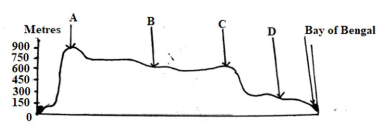
2×Board 2024Sample 20233/4 marks
In the figure given below, B is the Deccan Plateau. Name the features marked A and C. What are the two significant differences between these features?
16. Explain the geological evolution of the Himalayas
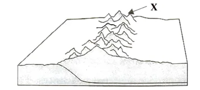
2×Board 2023Board 20252 marks
Briefly explain the geological evolution of the relief feature marked 'X' below.
Drainage Systems of India
17. Map: identify the river marked (Narmada, Chenab, Kosi, Krishna, Godavari, Damodar...)
9×Board 2023Board 2024Board 2025Board 2026Sample 2023Sample 2024Sample 2025Sample 2026Sample 20271 marks
Identify the correct option and label it on the outline map provided. The tributary of river Indus with the longest length marked P is:
(a) Ravi
(b) Sutlej
(c) Jhelum
(d) Chenab
18. Differences between Himalayan and Peninsular rivers
5×Board 2024Board 2025Sample 2025Sample 2026Sample 20272/4 marks
The Himalayan rivers are still youthful, while the Peninsular rivers have attained maturity. Examine the given statement.
19. Brahmaputra floods: causes, lifeline vs destruction
2×Sample 2025Sample 20272/4 marks
Examine the paradox of the River Brahmaputra as an agent of massive destruction and a vital lifeline for Assam's economy and ecology.
20. MCQ: identify a river from its characteristic (perennial, headstreams)
2×Board 2023Sample 20231 marks
The only perennial river of South India is:
(a) Godavari.
(b) Krishna.
(c) Kaveri.
(d) Narmada.
Climate of India
21. Climate graph/data: compare temperature and rainfall of two stations
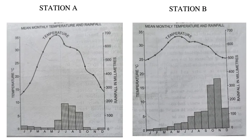
4×Sample 2023Sample 20272/3/4 marks
Study the Rainfall and Temperature graphs for Station A and Station B. Comment on the rainfall distribution pattern in both the Stations. Give a reason for the variation in the rainfall distribution.
22. Tropical cyclones: conditions causing them and states affected
3×Board 2025Sample 20262 marks
[context: Cyclone Dana, a severe cyclonic storm with winds up to 110 kmph, made landfall on coastal Odisha on 24 October 2024 (IMD).] What climatic conditions in India and its surrounding water bodies led to the phenomenon described above?
23. Climate graph: give reasons for the rainfall/source of rainfall at a station
4×Board 2024Board 20251 marks
Study the graph given for Station A. Provide a reason for the following: Low rainfall in the months of June and July.
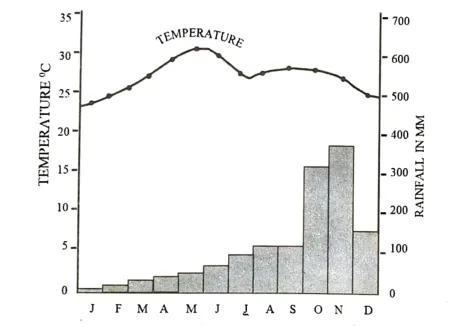
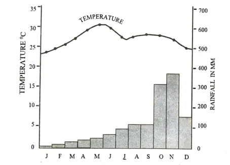
24. Climate graph/data: is the station coastal (maritime) or continental? Give a reason
3×Board 2024Board 2025Sample 20262 marks
Study the graph given for Station A. Does Station A experience a continental or a maritime climate? Give a reason for your answer.
25. Rainfall variability in India (Jaisalmer / paradox of distribution)
2×Board 2026Sample 20272/4 marks
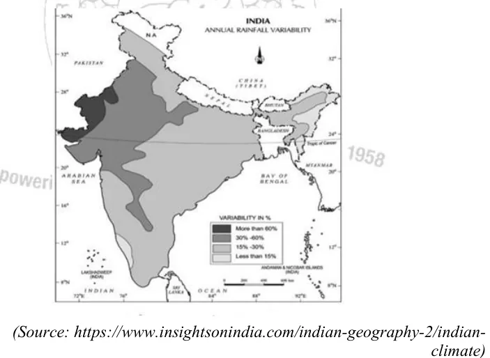
Study the map of India which shows areas of annual rainfall variability. Comment on the paradox of rainfall distribution in India.
26. Factors affecting temperature variations in India
2×Sample 2024Sample 20262/4 marks
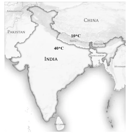
Observe the map given and account for the difference in temperature.
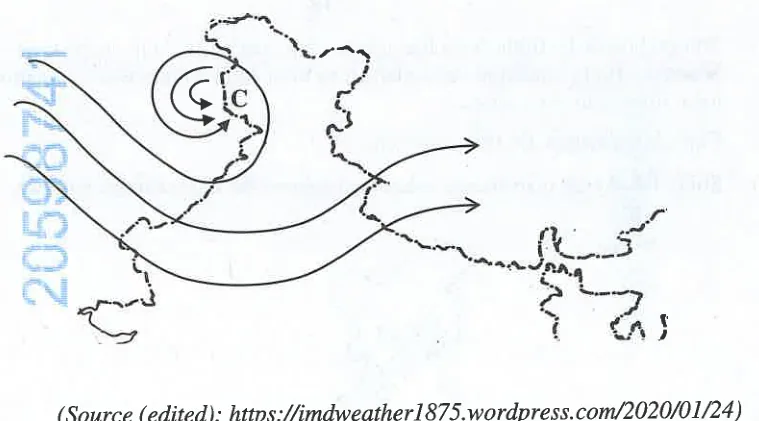
27. Effects of western disturbances on climate and agriculture
2×Board 2026Sample 20242/3 marks
Study the map given below and answer the question that follows. Discuss the effects of the weather phenomenon, depicted above, on Indian climate and agriculture.
Natural Vegetation and Forests
28. Social forestry: types (urban, agro, community) and people's participation
5×Board 2024Board 2026Sample 2025Sample 20272/3/4 marks
Social forestry is often described as forestry of the people, for the people and by the people. Do you agree? Justify.
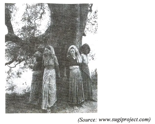
29. Chipko movement / Van Mahotsav: significance and impact
3×Board 2025Board 2026Sample 20242/3/4 marks
[context: photograph of women hugging a tree (Chipko movement)] Briefly explain any three impacts of the environmental movement, depicted above, on the Indian society.
30. Ways to increase forest cover / area under forests
2×Sample 2024Sample 20272 marks
If you were an Officer in the State Forest Department, what steps would you have taken to increase the forest cover in the state?
31. Objectives of the National Forest Policy, 1988
2×Board 2025Sample 20262/4 marks
[context: The Nagar Van Yojana (urban forest scheme) launched in 2020 resulted in an increase of 1445.81 km of tree and forest cover (India State of Forest Report 2023).] State two objectives of the National Forest Policy based on the 'Yojana' mentioned above.
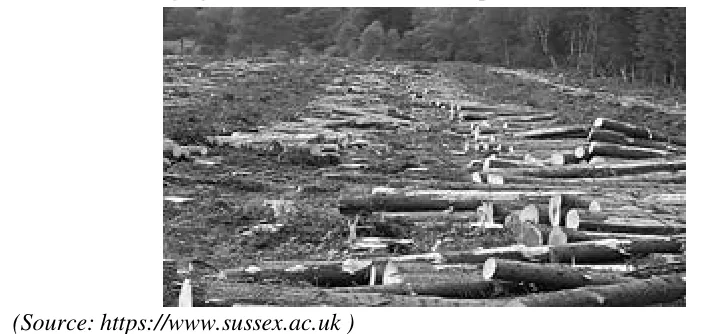
32. Need for forest conservation / problems of deforestation
2×Sample 2024Sample 20253/4 marks
Observe the image given below and answer the questions that follow. Explore the problems related to the situation depicted in the image.
Population of India
33. Map: state with highest/lowest density, literacy, urbanisation or index of concentration
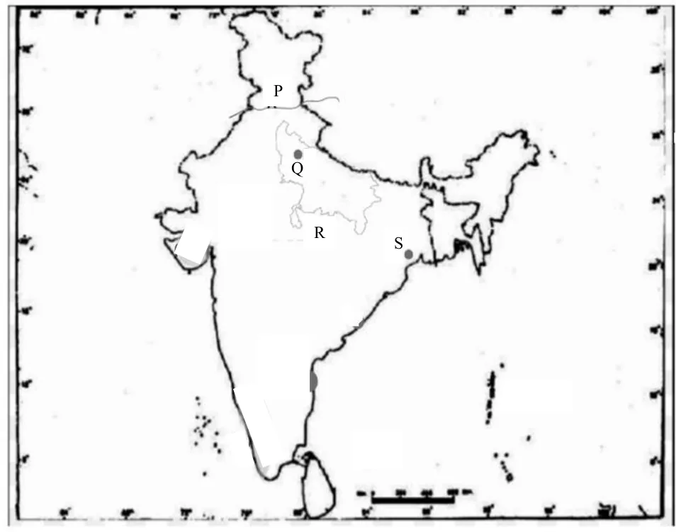
7×Board 2023Board 2025Board 2026Sample 2023Sample 2025Sample 2026Sample 20271 marks
Identify the correct option and label it on the outline map provided. The state with the highest index of concentration of population marked R:
(a) Bihar
(b) West Bengal
(c) Uttar Pradesh
(d) Madhya Pradesh
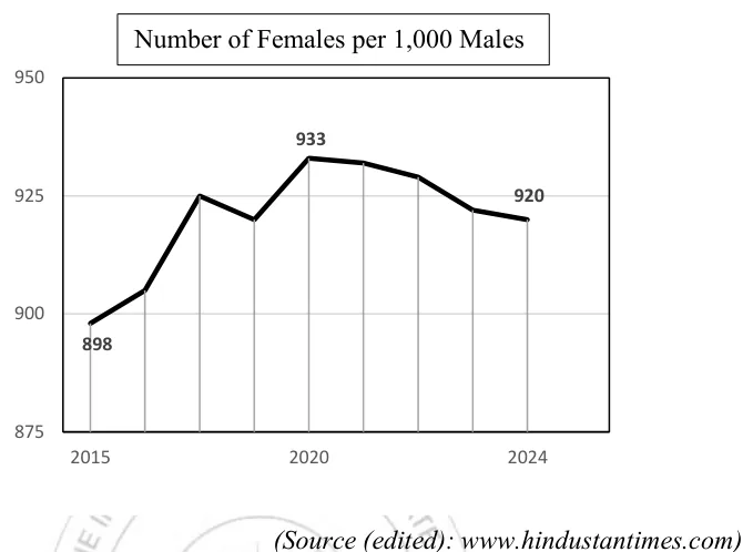
34. Sex ratio in India: trend and reasons for low sex ratio
3×Board 2025Sample 2023Sample 20272/4 marks
Study the line graph below and answer the question that follows. What trend does the graph reveal about the sex ratio of the population in India? Discuss three factors that have led to this sex ratio.
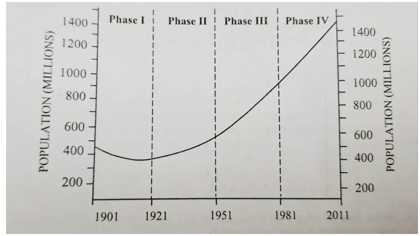
35. Population growth graph 1901-2011: reasons for growth in Phase III
2×Board 2025Sample 20262/3 marks
The graph given represents demographic transition in India during the years 1901-2011. Phase III indicates a significant change in the population of India. Give any three reasons to account for this change.
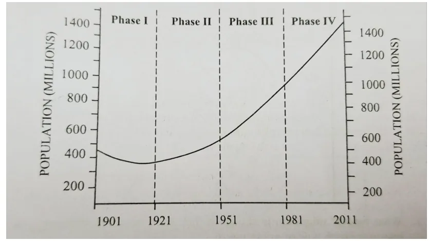
36. Why is 1921 called the year of the great demographic divide?
2×Board 2025Sample 20262 marks
The graph given represents demographic transition in India during the years 1901-2011. Why is the year 1921 called a year of demographic divide? Give any two reasons for your answer.
37. Name the state with the highest/lowest population density (Census)
2×Board 2023Sample 20241 marks
According to the latest census, the state with the lowest density of population in India is ______.
38. Non-working population / dependency ratio and its implications
2×Board 2023Sample 20232 marks
Briefly discuss the implications of non-working population on the country's development.
Migration
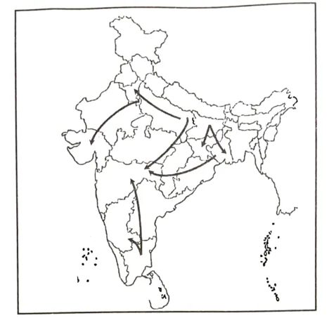
39. Types and streams of migration (identify and explain)
4×Board 2023Board 2025Sample 2025Sample 20272/3 marks
Study the sketch map given below and answer the question that follows. What type of migration is shown in the above map? Provide any one reason for such type of migration.
40. Causes of migration (rural to urban) and factors determining migrants' movement
4×Board 2023Board 2024Sample 20232/3 marks
[context: The flow of migrants to urban cities has been increasing, exerting immense pressure on resources in urban centres.] State any three factors that determine the movement of migrants in the area referred to above.
41. Problems caused by migration to urban areas
2×Board 2024Board 20263/4 marks
Discuss any three problems caused by migration from rural to urban areas.
Human Settlements
42. Urban agglomeration and urban sprawl: causes, impacts, pros and cons
4×Board 2026Sample 2024Sample 20252/3 marks
Urban sprawl is the low-density expansion of cities into surrounding rural areas. What are the two impacts of this type of urban development?
43. Compact vs dispersed rural settlements: types and characteristics
4×Board 2026Sample 2024Sample 20252/4 marks
Mention any two characteristic features of compact rural settlements in India.
44. Factors for the growth of urban centres
3×Board 2025Sample 2025Sample 20262 marks
Discuss any two factors which determine evolution of urban settlements.
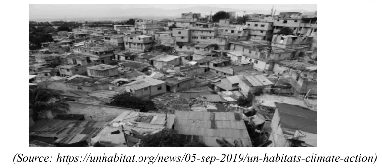
45. Problems of urbanisation and slums
2×Sample 2023Sample 20274 marks
The settlement shown in the given image is growing at an accelerated rate and has turned to be a major problem of urbanisation in today's India. Discuss four problems associated with it.
46. Urban area (Census definition) and rural vs urban settlements
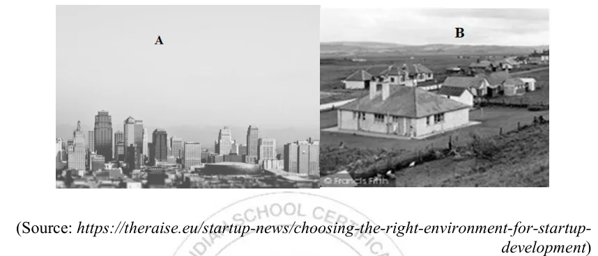
2×Board 2023Sample 20274 marks
Study the two types of settlements shown in the images below and answer the question that follows. Differentiate between the two settlements marked 'A' and 'B' based on occupation and population density.
47. Factors affecting the type, location and size of rural settlements
2×Board 2023Sample 20262 marks
Rural settlements in Rajasthan are large and inhabited by over ten thousand people. Explain any two factors influencing location and size of rural settlements in Rajasthan.
Environment and Land Resources
48. Fallow land: identify it and why land is left fallow
3×Board 2024Sample 20231 marks
The land left uncultivated for a period of one to five years to help soil regain its fertility is called ______.
49. Net sown area: objective questions
2×Board 2026Sample 20261 marks
The Net Sown Area in India needs to be increased. Choose the correct reasons that justify the above statement.
(P) Forest area has to be expanded.
(Q) Quality of cultivable land is high.
(R) Food requirements need to be fulfilled.
(S) Agricultural productivity needs to be improved.
(a) Only (P) and (Q)
(b) Only (Q) and (R)
(c) Only (R) and (S)
(d) Only (P) and (R)
50. Why is the area sown more than once low in India?
2×Board 2023Sample 20242 marks
Briefly explain why the 'area sown more than once' is low in India.
Water Resources and Irrigation
51. Rainwater harvesting and community water conservation
5×Board 2023Board 2026Sample 2024Sample 2026Sample 20272/4 marks
'Telangana followed by Chhattisgarh and Rajasthan leads in community-based water conservation projects under the Jal Sanchay Jan Bhagidari (JSJB) 1·0 initiative by the Government of India.' (deccanchronicle.com) Assess the reasons for the above-mentioned states leading in water conservation projects.
52. Modern methods of irrigation (drip, sprinkler) vs canal irrigation
3×Board 2024Board 2025Sample 20242/4 marks
Contrast between Canal irrigation and Drip irrigation on any four bases.
53. Overwatering and waterlogging (Punjab): problems and solutions
2×Sample 2023Sample 20264 marks
[context: Punjab, India's breadbasket, faces waterlogging due to its extensive canal irrigation system, particularly in the south-western districts, causing a decline in agricultural production and land value.] How do you think Punjab can balance its agricultural prosperity in spite of this pressing problem which threatens the fertility of land and sustainability of water resources?
Agriculture
54. Market gardening / horticulture: meaning and growing importance
4×Sample 2023Sample 2026Sample 20272/3/5 marks
[context: According to APEDA, India ranks first globally in production of bananas, mangoes, guavas and papayas, with vegetables like onions, tomatoes and green chillies dominating exports; Centrally Sponsored Schemes provide up to 85% funding for quality planting material and infrastructure.] Examine the reasons for the above-mentioned sector gaining importance in India in present times.
55. Second Green Revolution: strategies and their influence
5×Board 2024Board 2026Sample 20231/2/3/4 marks
[context: Excerpt - 'Drone Didi' women in the Varanasi region fly agricultural drones under a government scheme, helping agriculture move from traditional to market-oriented practices.] Which strategy of second green revolution has been referred to above?
Crops of India
56. Map: identify the leading producing state of a crop (tea, wheat, groundnut)
4×Board 2025Board 2026Sample 20241 marks
Label on the outline Map of India: The leading tea producing state of India, marked U is ______.
57. Conditions of growth of a crop (tea, cotton, groundnut, coconut)
4×Board 2023Board 2024Sample 20232/4 marks
State any two conditions that favour the cultivation of cotton in India.
58. Analogy: leading producing state of a crop/mineral (Jowar : Maharashtra :: Bajra : ?)
2×Board 2025Sample 20261 marks
Observe the relation between the first two words and fill in the fourth word.
Jowar: Maharashtra :: Bajra: ______
59. Impact of climate/adverse weather on sugarcane
2×Sample 2024Sample 20252/3 marks
[context: On January 17, 2023 Reuters reported that adverse weather - excessive rainfall and cloudy weather in September and October - has hit the Indian cane crop and will reduce sugar output.] Examine how such a climatic condition can adversely affect the sugarcane crop.
Minerals and Energy Resources
60. Map: identify the nuclear power station (Narora, Kalpakkam, Kaiga, Rawatbhata, Tarapur)
4×Board 2024Sample 2025Sample 2026Sample 20271 marks
Identify the correct option and label it on the outline map provided. The nuclear power plant located along the banks of river Ganga marked Q:
(a) Kaiga
(b) Narora
(c) Tarapur
(d) Rawatbhata
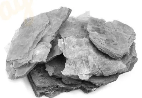
61. Mica: importance in electrical industry, leading state and demand
3×Board 2025Sample 20242/4 marks
[context: photograph of sheets of mica] Why is the metal shown above an important component in the electrical and electronic industry?
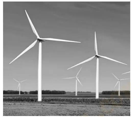
62. Importance and advantages of non-conventional energy (wind, solar, biogas)
3×Board 2024Board 2026Sample 20242/4 marks
[context: photograph of wind turbines] Why is the energy generated by the above source considered important?
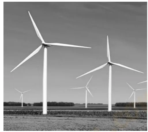
63. Thermal (conventional) power compared with hydel / non-conventional energy
3×Board 2023Sample 2023Sample 20242 marks
[context: photograph of wind turbines] Give any two differences between the thermal power and the energy source shown above.
64. Hydel power (image): favourable conditions for generation
2×Board 2024Sample 20252 marks
[context: photograph of a dam releasing water (hydel power)] State any two conditions that are favourable for generation of power from the energy source shown above.
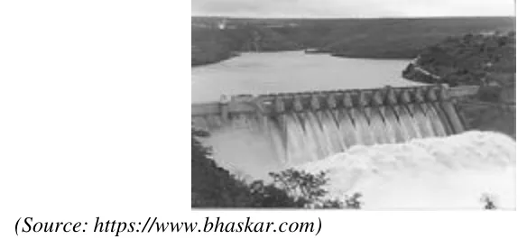
65. Hydel power: significance for sustainable development
2×Board 2024Sample 20252 marks
[context: photograph of a dam releasing water (hydel power)] Briefly discuss the significance of this energy source in ensuring sustainable development.
66. Coal (image): uses of the fossil fuel shown
2×Board 2024Sample 20252 marks
[context: photograph of lumps of coal held in hands] The image given above shows a fossil fuel that has versatile uses. Mention any two of its uses.
67. Coal: disadvantages of the fossil fuel
2×Board 2024Sample 20252 marks
[context: photograph of lumps of coal held in hands] State any two disadvantages of this fossil fuel.
Transport and Trade
68. Map: identify the port marked (Kolkata, Haldia, Kochi, Mumbai, Chennai)
8×Board 2023Board 2024Board 2025Board 2026Sample 2024Sample 2025Sample 2026Sample 20271 marks
Identify the correct option and label it on the outline map provided. The port built to decongest the oldest port in eastern India marked S:
(a) Kochi
(b) Haldia
(c) Kolkata
(d) Chennai
69. Map: terminal towns of the Golden Quadrilateral / North-South / East-West corridor
6×Board 2023Board 2024Board 2026Sample 2023Sample 2024Sample 20251 marks
Refer to the given outline Map of India, identify the correct option and label on the Map. One of the terminal towns of the Golden Quadrilateral, marked P is:
(a) Delhi
(b) Chennai
(c) Mumbai
(d) Kolkata
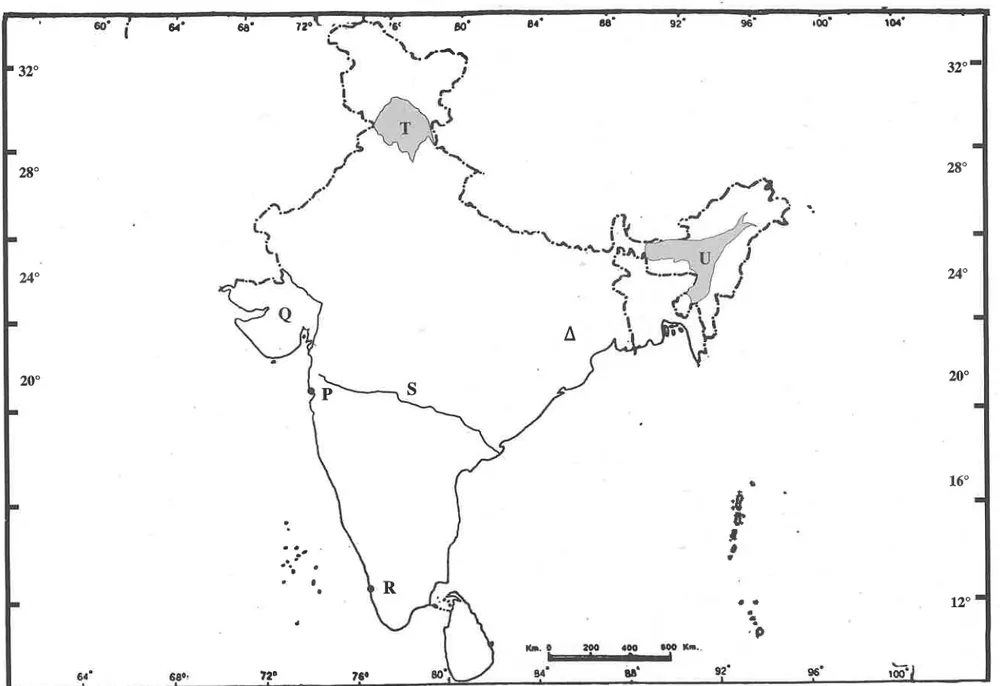
70. Role of transport (roads, railways) in industrial and regional development
4×Board 2024Sample 2024Sample 2026Sample 20273/4 marks
Study the sketch map given below and answer the questions that follow. Give any three reasons to justify that such transport projects strengthen the industrial economy of India.
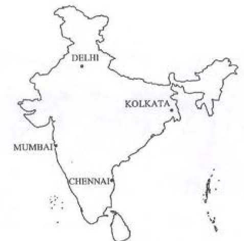
71. Roads and railways complement each other (roads as feeders)
2×Sample 2026Sample 20272/4 marks
How do road and railways complement each other in a modern economy?
72. Distribution of the railway network (dense in Northern Plains, absent in NE)
2×Board 2026Sample 20262 marks
Explain two reasons for the presence of a dense railway network in the Northern plains.
Communication
73. Role of satellites in communication and development
3×Board 2023Board 20253/4 marks
[context: Passage - Union Transport Minister announced a new satellite based toll collection system that charges by distance travelled, saving time and fuel.] How will the development of the new satellite system, referred to above, accelerate industrialisation?
74. Radio as an important means of mass communication in India
2×Board 2026Sample 20232/4 marks
Radio continues to be a major means of mass communication in India. Comment.
Industries
75. Map: identify the industrial centre marked (iron & steel, cotton textile, sugar)
6×Board 2023Board 2026Sample 2023Sample 2024Sample 2025Sample 20261 marks
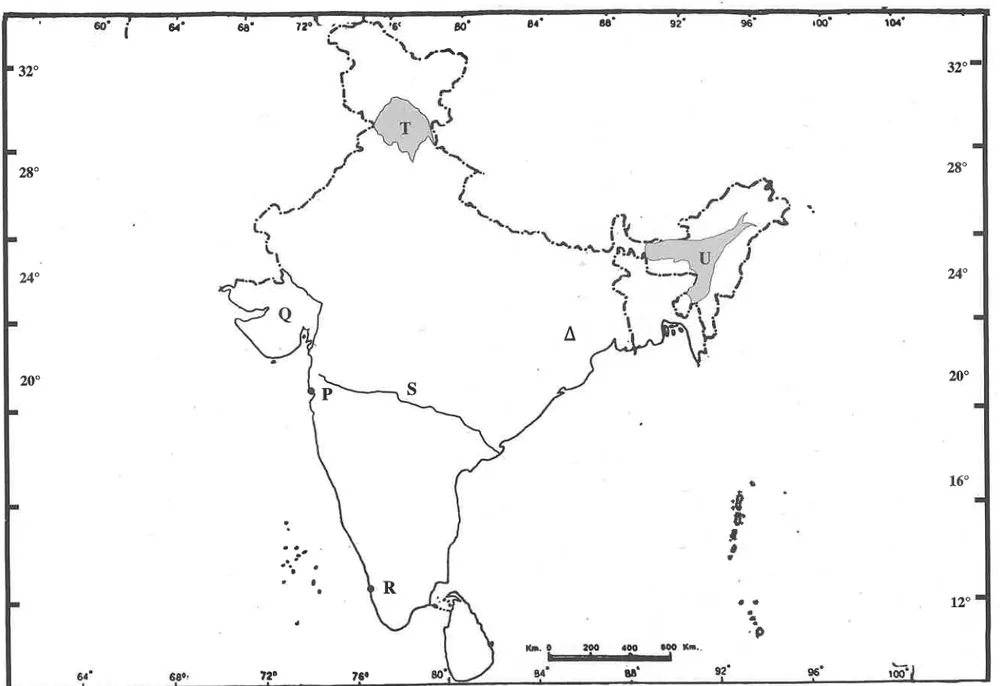
Refer to the given outline Map of India, identify the correct option and label on the Map. The iron and steel industry marked with Δ, is located in:
(a) Bhilai
(b) Bokaro
(c) Jamshedpur
(d) Visakhapatnam
76. Factors of industrial location and uneven distribution of industries
3×Board 2024Sample 2026Sample 20271/2 marks
What is the role of raw material in determining the location of industries in India?
77. Major industrial regions: factors for growth
3×Board 2026Sample 20252/3/4 marks
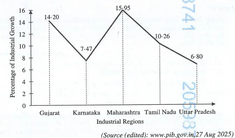
Annual Survey of Industries is conducted by the Indian government to measure the growth of various manufacturing industries in a year. The following graph, based on the survey, depicts a region wise percentage of industrial growth in India for the year 2023-24. Identify the fastest growing industrial region. Analyse any one factor that is responsible for its growth.
78. Role of the iron and steel industry in India's economic development
2×Sample 2026Sample 20271/2 marks
Examine the role of iron and steel industry in the economic development of India.
79. Cotton textile industry: need, growth and challenges
2×Sample 2023Sample 20262 marks
Analyse the growth and challenge of the cotton textile industries in India.
80. Map: identify the oil refinery marked (Barauni, Digboi, Haldia)
2×Board 2025Sample 20261 marks
Label on the outline Map of India: The oil refinery marked S is ______.
81. Sugar industry: growth in Maharashtra and shift to peninsular India
2×Board 2026Sample 20242/4 marks
There is a gradual shift of the sugar industry from North India to Peninsular India. Briefly explain any two reasons for this transition.
Tourism
82. Eco-tourism / responsible tourism: need and advantages
4×Board 2023Board 2025Sample 20251/2/3 marks
[context: "Indian tourism promotes sustainable, responsible and inclusive development of tourism in the country"] What does the word 'responsible' imply in the context of tourism? State two ways in which responsible tourism is practised in India.
83. International tourist arrivals: why low and how to increase
2×Sample 2025Sample 20262/4 marks
[context: extract (poem) - tourist arrivals in India have been delayed post pandemic while neighbours woo international tourists; India lives in a non-competitive way.] In context of the above, suggest any two ways by which India can increase the inflow of international tourists.
84. Tourism as a source of revenue, employment and regional development
2×Board 2025Sample 20274 marks
How does the growth of tourism industry contribute to employment generation and regional economic development in India?
Regional Economic Development
85. Macro, meso and micro planning regions
3×Board 2023Board 20261/4 marks
Give a reason for the following: The Ganga Plains is a macro region.
86. Multilevel / block level planning and planning regions
2×Sample 2023Sample 20262/4 marks
Why is there a need to practise Block level planning?
87. Chhattisgarh region: mining and agriculture
2×Board 2024Sample 20262/3 marks
Chhattisgarh is predominantly an agricultural state. Give three reasons to support the statement.
88. Haldia port and hinterland as a planning region: requirements/reasons
2×Board 2025Sample 20242/4 marks
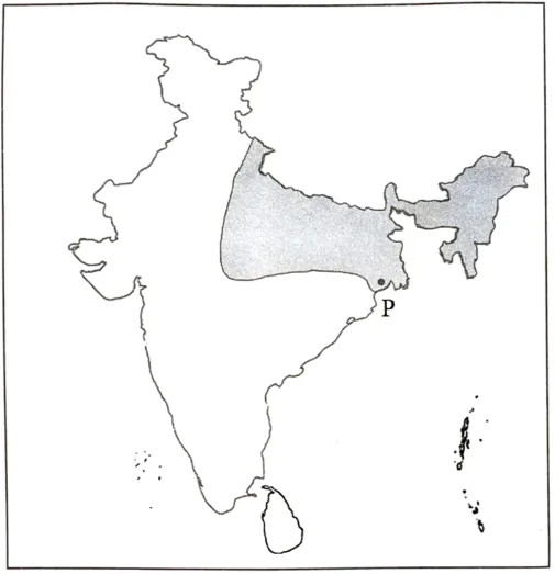
Study the sketch map given below and answer the questions that follow. State any four reasons for the development of a planning region like the one shown above.
89. Why is Bengaluru the 'Electronics Capital' of India?
2×Board 2026Sample 20232/3 marks
Examine any two factors that have led to the growth of Bengaluru as the 'Capital of Electronics'.
90. Haldia port: reasons for its establishment and growth
2×Board 2023Board 20253 marks
Study the sketch map given below and answer the questions that follow. What has led to the establishment of the port marked P? Name any two industries that have led to its further growth.