ISC Class 12 Geography Guess Paper 2027
Last updated:
A full practice paper on the official Geography pattern, built from the most-likely questions by repetition analysis. Not an official or leaked paper.
ISC Class 12 Geography — Guess Paper 2027
Time: 3 hours · Maximum marks: 70 · Practice paper
Section ACompulsory, 14 marks. Question 1 (8 marks): map work on the outline map of India - mark and label the correct option / identify the feature marked on the map. Question 2 (6 marks): two assertion-reason items, one choose-the-correct-reasons MCQ and three one-mark very-short-answer reasoning items.
Q1.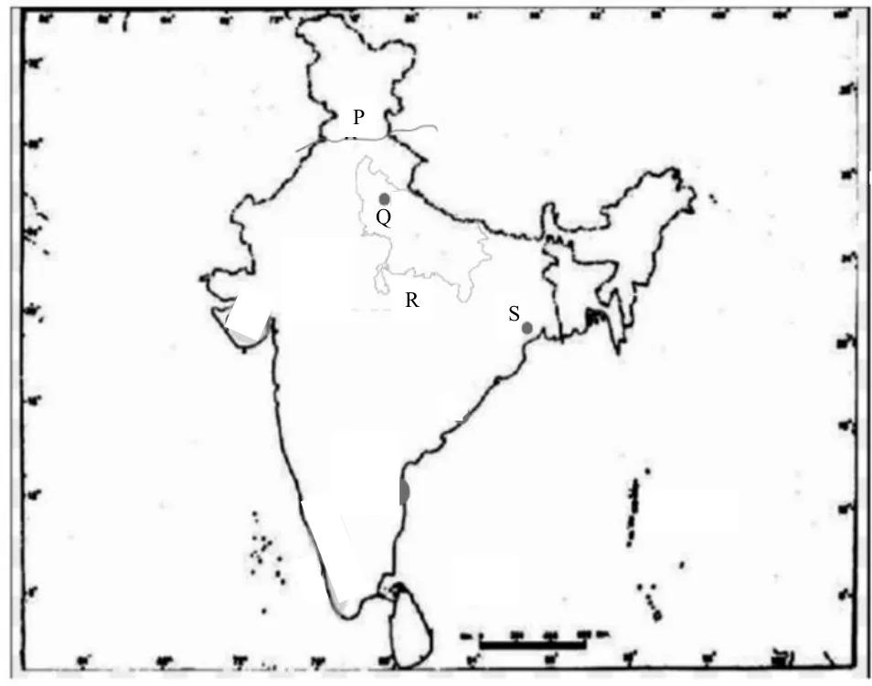 1 mark
Identify the correct option and label it on the outline map provided. The tributary of river Indus with the longest length marked P is:
(a) Ravi
(b) Sutlej
(c) Jhelum
(d) Chenab
Why this question: Drainage Systems of India → Map: identify the river marked (Narmada, Chenab, Kosi, Krishna, Godavari, Damodar...) — appeared 9× Board 2023Board 2024Board 2025Board 2026Sample 2023Sample 2024Sample 2025Sample 2026Sample 2027
Q2.1 mark
Mark and label the correct option on the outline map provided. A large brackish waterbody on the Coromandel coast is:
(a) Pulicat
(b) Wular
(c) Chilika
(d) Sambar
Why this question: Structure and Physiography of India → Map: mark and label a water body (Palk Strait, Gulf of Kachchh/Khambhat, Chilika, Pulicat) — appeared 8× Board 2024Board 2025Board 2026Sample 2023Sample 2024Sample 2025Sample 2026Sample 2027
Q3.1 mark
Identify the correct option and label it on the outline map provided. The port built to decongest the oldest port in eastern India marked S:
(a) Kochi
(b) Haldia
(c) Kolkata
(d) Chennai
Use the map given in Q1.
Why this question: Transport and Trade → Map: identify the port marked (Kolkata, Haldia, Kochi, Mumbai, Chennai) — appeared 8× Board 2023Board 2024Board 2025Board 2026Sample 2024Sample 2025Sample 2026Sample 2027
Q4.1 mark
Mark and label on the outline Map of India: The hills where Eastern Ghats and Western Ghats meet.
Why this question: Structure and Physiography of India → Map: mark and label a mountain range (Aravallis, Satpura, Western Ghats, Nilgiris, Himadri, Karakoram) — appeared 8× Board 2023Board 2024Board 2025Board 2026Sample 2023Sample 2024Sample 2025Sample 2026
Q5.1 mark
Identify the correct option and label it on the outline map provided. The state with the highest index of concentration of population marked R:
(a) Bihar
(b) West Bengal
(c) Uttar Pradesh
(d) Madhya Pradesh
Use the map given in Q1.
Why this question: Population of India → Map: state with highest/lowest density, literacy, urbanisation or index of concentration — appeared 7× Board 2023Board 2025Board 2026Sample 2023Sample 2025Sample 2026Sample 2027
Q6.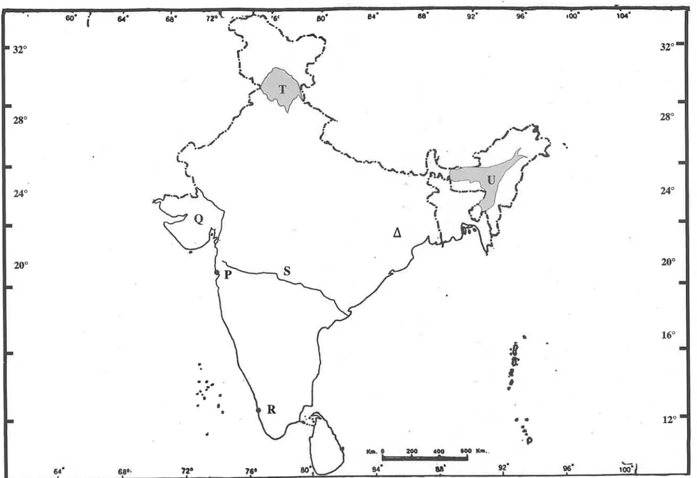 1 mark
Refer to the given outline Map of India, identify the correct option and label on the Map. The iron and steel industry marked with Δ, is located in:
(a) Bhilai
(b) Bokaro
(c) Jamshedpur
(d) Visakhapatnam
Why this question: Industries → Map: identify the industrial centre marked (iron & steel, cotton textile, sugar) — appeared 6× Board 2023Board 2026Sample 2023Sample 2024Sample 2025Sample 2026
Q7.1 mark
Mark and label the correct option on the outline map provided. The coastal plains where the port of Kochi is located:
(a) Konkan
(b) Kanara
(c) Malabar
(d) Northern Circars
Why this question: Structure and Physiography of India → Map: mark and label a coastal plain (Konkan, Kanara, Malabar, Coromandel, Northern Circars) — appeared 6× Board 2023Board 2024Sample 2023Sample 2024Sample 2025Sample 2027
Q8.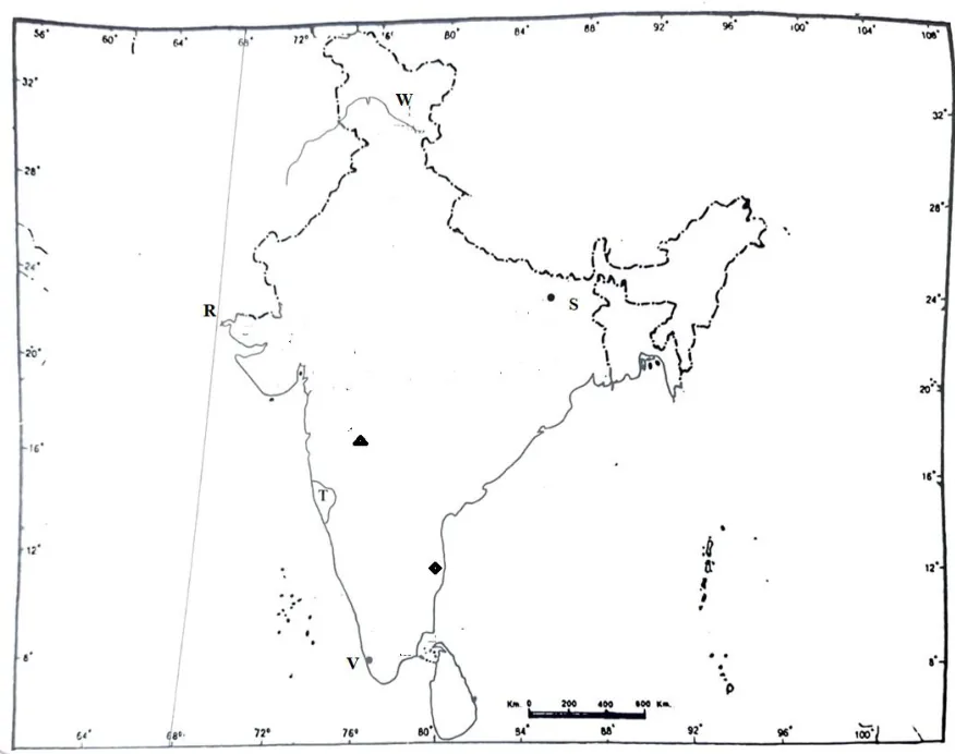 1 mark
Refer to the given outline Map of India, identify the correct option and label on the Map. The longitude of India marked R:
(a) 68°7'E
(b) 78°30'E
(c) 23°30'N
(d) 97°25'E
Why this question: Locational Setting of India → Map: identify the latitude/longitude marked (8°4'N, 37°6'N, 68°7'E, 97°25'E, 23°30'N, 82°30'E) — appeared 6× Board 2023Board 2025Sample 2023Sample 2024Sample 2025Sample 2026
Q9.1 mark
Assertion: India aims to increase the generation of non-conventional energy by 2030.
Reason: Conventional resources cause pollution and are non-renewable.
(a) Both Assertion and Reason are true and Reason is the correct explanation for Assertion.
(b) Both Assertion and Reason are true but Reason is not the correct explanation for Assertion.
(c) Assertion is true and Reason is false.
(d) Both Assertion and Reason are false.
Why this question: Minerals and Energy Resources → Assertion-Reason: need for non-conventional/nuclear energy in India — appeared 2× Sample 2027
Q10.1 mark
The Net Sown Area in India needs to be increased. Choose the correct reasons that justify the above statement.
(P) Forest area has to be expanded.
(Q) Quality of cultivable land is high.
(R) Food requirements need to be fulfilled.
(S) Agricultural productivity needs to be improved.
(a) Only (P) and (Q)
(b) Only (Q) and (R)
(c) Only (R) and (S)
(d) Only (P) and (R)
Why this question: Environment and Land Resources → Net sown area: objective questions — appeared 2× Board 2026Sample 2026
Q11.1 mark
The country that India does NOT share a land border with is:
(a) Nepal
(b) Bhutan
(c) Sri Lanka
(d) Afghanistan
Why this question: Locational Setting of India → MCQ: India's land borders with neighbouring countries — appeared 2× Sample 2023Sample 2024
Q12.1 mark
What is the role of raw material in determining the location of industries in India?
Why this question: Industries → Factors of industrial location and uneven distribution of industries — appeared 3× Board 2024Sample 2026Sample 2027
Q13.1 mark
Examine the role of iron and steel industry in the economic development of India.
Why this question: Industries → Role of the iron and steel industry in India's economic development — appeared 2× Sample 2026Sample 2027
Q14.1 mark
The land left uncultivated for a period of one to five years to help soil regain its fertility is called ______.
Why this question: Environment and Land Resources → Fallow land: identify it and why land is left fallow — appeared 3× Board 2024Sample 2023
Section BSeven short-answer questions of four marks each (28 marks); five are whole 4-mark questions (often based on a graph, data table, sketch map or source) and two are split into 2+2-mark parts. Internal choices are provided in three of these questions.
Q15.4 marks
The Himalayan rivers are still youthful, while the Peninsular rivers have attained maturity. Examine the given statement.
Why this question: Drainage Systems of India → Differences between Himalayan and Peninsular rivers — appeared 5× Board 2024Board 2025Sample 2025Sample 2026Sample 2027
Q16.4 marks
'Telangana followed by Chhattisgarh and Rajasthan leads in community-based water conservation projects under the Jal Sanchay Jan Bhagidari (JSJB) 1·0 initiative by the Government of India.' (deccanchronicle.com) Assess the reasons for the above-mentioned states leading in water conservation projects.
Why this question: Water Resources and Irrigation → Rainwater harvesting and community water conservation — appeared 5× Board 2023Board 2026Sample 2024Sample 2026Sample 2027
Q17.4 marks
Social forestry is often described as forestry of the people, for the people and by the people. Do you agree? Justify.
Why this question: Natural Vegetation and Forests → Social forestry: types (urban, agro, community) and people's participation — appeared 5× Board 2024Board 2026Sample 2025Sample 2027
Q18.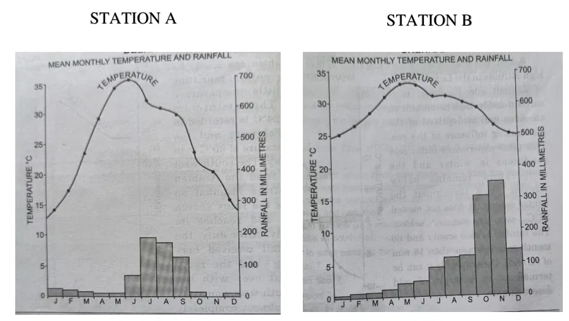 4 marks
Study the Rainfall and Temperature graphs for Station A and Station B. Briefly explain the relationship between temperature and rainfall in both the Stations.
Why this question: Climate of India → Climate graph/data: compare temperature and rainfall of two stations — appeared 4× Sample 2023Sample 2027
Q19.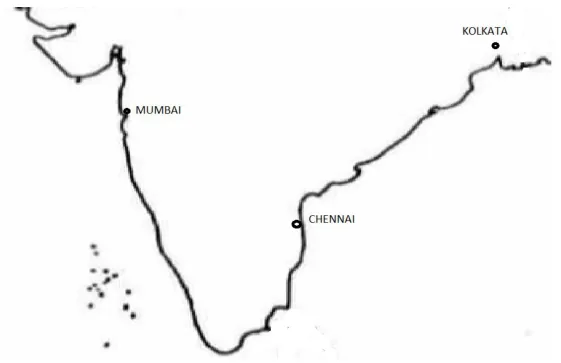 4 marks
Roads and railways have connected the three ports in India as shown in the map given. How did this connectivity influence industrialisation in pre independent India?
Why this question: Transport and Trade → Role of transport (roads, railways) in industrial and regional development — appeared 4× Board 2024Sample 2024Sample 2026Sample 2027
Q20.4 marks
Discuss any four strategies of the Second Green Revolution.
Why this question: Agriculture → Second Green Revolution: strategies and their influence — appeared 5× Board 2024Board 2026Sample 2023
Q21.2 marks
Indian Ocean acts as a global link. Justify the statement by giving two reasons.
Why this question: Locational Setting of India → Significance of India's location in the Indian Ocean ('Mistress of the Eastern Seas') — appeared 5× Board 2025Board 2026Sample 2024Sample 2025Sample 2026
Q22.2 marks
How has market gardening helped in agricultural diversification?
Why this question: Agriculture → Market gardening / horticulture: meaning and growing importance — appeared 4× Sample 2023Sample 2026Sample 2027
Section CFour long-answer questions of seven marks each (28 marks), each split into parts (4+3 or 5+2); the last question is based on a passage/case. Internal choices are provided in two of these questions.
Q23.4 marks
Briefly discuss any two rural settlement types and any two of their characteristics.
Why this question: Human Settlements → Compact vs dispersed rural settlements: types and characteristics — appeared 4× Board 2026Sample 2024Sample 2025
Q24.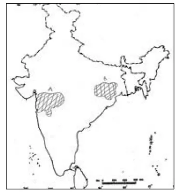 4 marks
Refer to the sketch map given which shows two industrial regions of India marked A and B. Explain any four factors responsible for the growth of the industry in region A.
Why this question: Industries → Major industrial regions: factors for growth — appeared 3× Board 2026Sample 2025
Q25.4 marks
Outline two major challenges faced by Indian transport. Propose two strategies to overcome them.
Why this question: Transport and Trade → Problems of Indian transport and role of technology — appeared 2× Sample 2027
Q26.3 marks
The National Capital Region (NCR) in India is one of the largest and most populous urban agglomeration in the country, including Delhi and surrounding urban areas such as Gurugram, Noida, Ghaziabad and Faridabad. What is an urban agglomeration? How has rapid urbanisation increased the challenges faced by the above-mentioned urban agglomeration?
Why this question: Human Settlements → Urban agglomeration and urban sprawl: causes, impacts, pros and cons — appeared 4× Board 2026Sample 2024Sample 2025
Q27.3 marks
What migration pattern is observed in the advanced stage of migration? Why?
Why this question: Migration → Types and streams of migration (identify and explain) — appeared 4× Board 2023Board 2025Sample 2025Sample 2027
Q28.3 marks
[context: The flow of migrants to urban cities has been increasing, exerting immense pressure on resources in urban centres.] State any three factors that determine the movement of migrants in the area referred to above.
Why this question: Migration → Causes of migration (rural to urban) and factors determining migrants' movement — appeared 4× Board 2023Board 2024Sample 2023
Q29.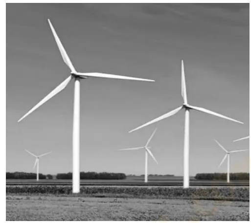 5 marks
[context: photograph of wind turbines] Why is the energy generated by the above source considered important?
Why this question: Minerals and Energy Resources → Importance and advantages of non-conventional energy (wind, solar, biogas) — appeared 3× Board 2024Board 2026Sample 2024
Q30.2 marks
[context: Passage - Alice visited a crowded hill station with polluted lakes and approached local authorities to protect the environment.] Give any two points on the need to develop eco-tourism in India.
Why this question: Tourism → Eco-tourism / responsible tourism: need and advantages — appeared 4× Board 2023Board 2025Sample 2025